Format
Full
City
Cypress
State/Province
TX
Country
USA
Metro Area
Houston
Project Type
Planned Community or Resort
Location Type
Outer Suburban
Land Uses
Civic Uses
Community Center
Conservation Zone
Education
Fitness Center
Lake
Multifamily Rental Housing
Neighborhood/Community Center
Off-Road Trails
Office
Open space
Planned Community
Recreation
Religious Use
Single-family Detached Housing
Single-Family For-Sale Housing
Streets
Water Uses/Amenities
Keywords
Freshwater reservoir
Graywater reclamation
Healthy place features
Main street design
Mixed-use town center
Park system
Playground
School
Single-family detached housing
Stormwater management
Stormwater reuse system
Town center
Traditional neighborhood development
Waterfront
Site Size
11400
acres
acres
hectares
Date Started
2004
Date Opened
2007
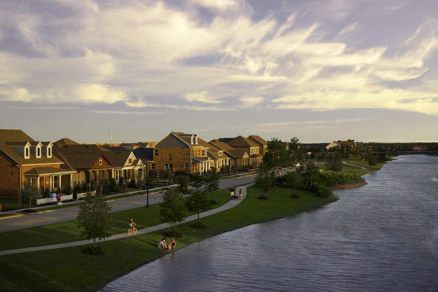
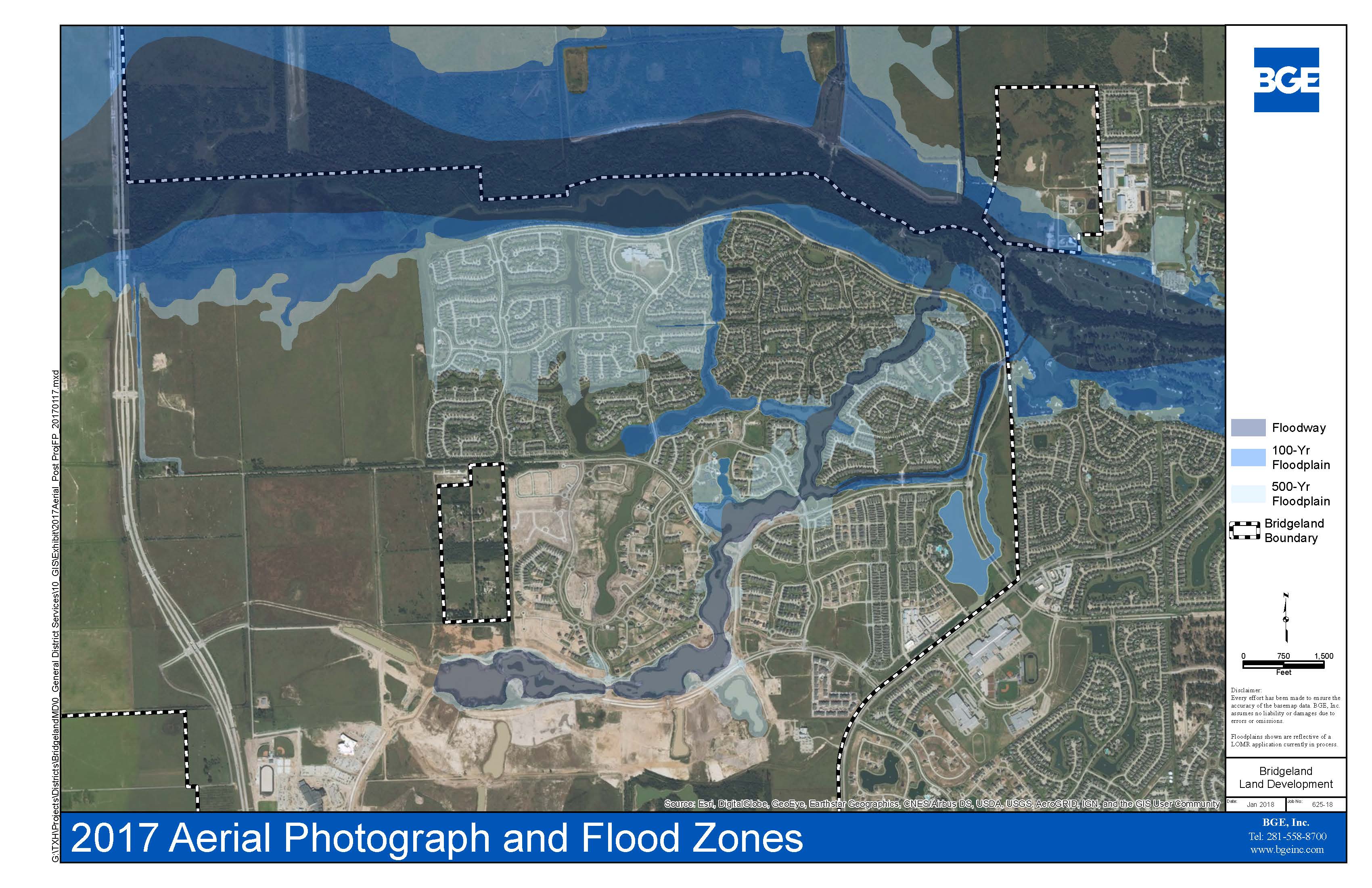
Bridgeland is an 11,400-acre master-planned community northwest of Houston, Texas, which will be home to 65,000 residents when complete in 2037. Like the Woodlands, its predecessor, the Bridgeland site plan centers on scenic lakes that improve water quality, irrigate during droughts, and draw residents to common areas for recreation. These lakes form a stormwater system that exceeds local design requirements, and which has managed storm events much larger than those anticipated.
Access to this robust content is a key benefit of ULI membership.
Become a member today to gain unlimited access to ULI Case Studies.
Become a Member Learn more about membership[ The Idea and the Site | Planning and Design | Approvals, Finance, and Construction | Performance, Marketing, and Management | Observations and Lessons Learned | Project Information ]
The Idea and the Site
The Howard Hughes Company (HHC) is a Dallas-based developer and operator of master-planned communities (MPCs) and mixed-use properties in 14 states. It is a successor of the Rouse Company, a pioneer in MPCs on the “new town” scale, including Columbia, Maryland; Summerlin, Nevada; and the Woodlands, Texas. In its investor materials, HHC says its large-scale MPC business “build[s] small cities that are their own ecosystems and high-barrier submarkets,” resulting in “some of the highest, risk-adjusted return opportunities” among public real estate companies.
Construction on the Woodlands, located 28 miles north of downtown Houston, began in 1966. It opened in 1974, and now has over 115,000 residents across more than 28,000 acres. Its pioneering design, helmed by influential landscape architect Ian McHarg, set a new standard for environmentally sensitive site planning, especially in the Houston region. “Builders found that they could love profits and trees at the same time,” said McHarg in 1975; preserving stands of trees and draining streets with bioswales both reduced upfront expenses and created a unique sense of place. (ULI awarded the Woodlands a 1994 Award for Excellence, and published a biography of its developer, George Mitchell, in 2004.)
As the Woodlands hit its stride in the 1990s, the developer began scouting for new sites elsewhere in the metropolitan area where it could replicate its success for a new audience. Much of Houston’s job growth in recent decades has occurred to the west and north, so the northwest sector along US 290 seemed like a strong bet. Rouse assembled a large site 25 miles from downtown, just beyond several 1980s subdivisions in the Cypress area, which has a well-regarded Cypress-Fairbanks (Cy-Fair) school district and a low crime rate. The site also sat astride the planned route of Grand Parkway (SH-99), a third beltway around Houston whose first leg opened in 1994. Its 2013 extension through Bridgeland, and its 2016 extension through the northern suburbs, offer nonstop access to job centers in the bustling I-10 Energy Corridor (see ULI Case Study, CityCentre) to the south and to Spring and the Woodlands to the northeast. (In 2017, HHC launched a third MPC in the region—the Woodlands Hills, ten miles north of the Woodlands.)

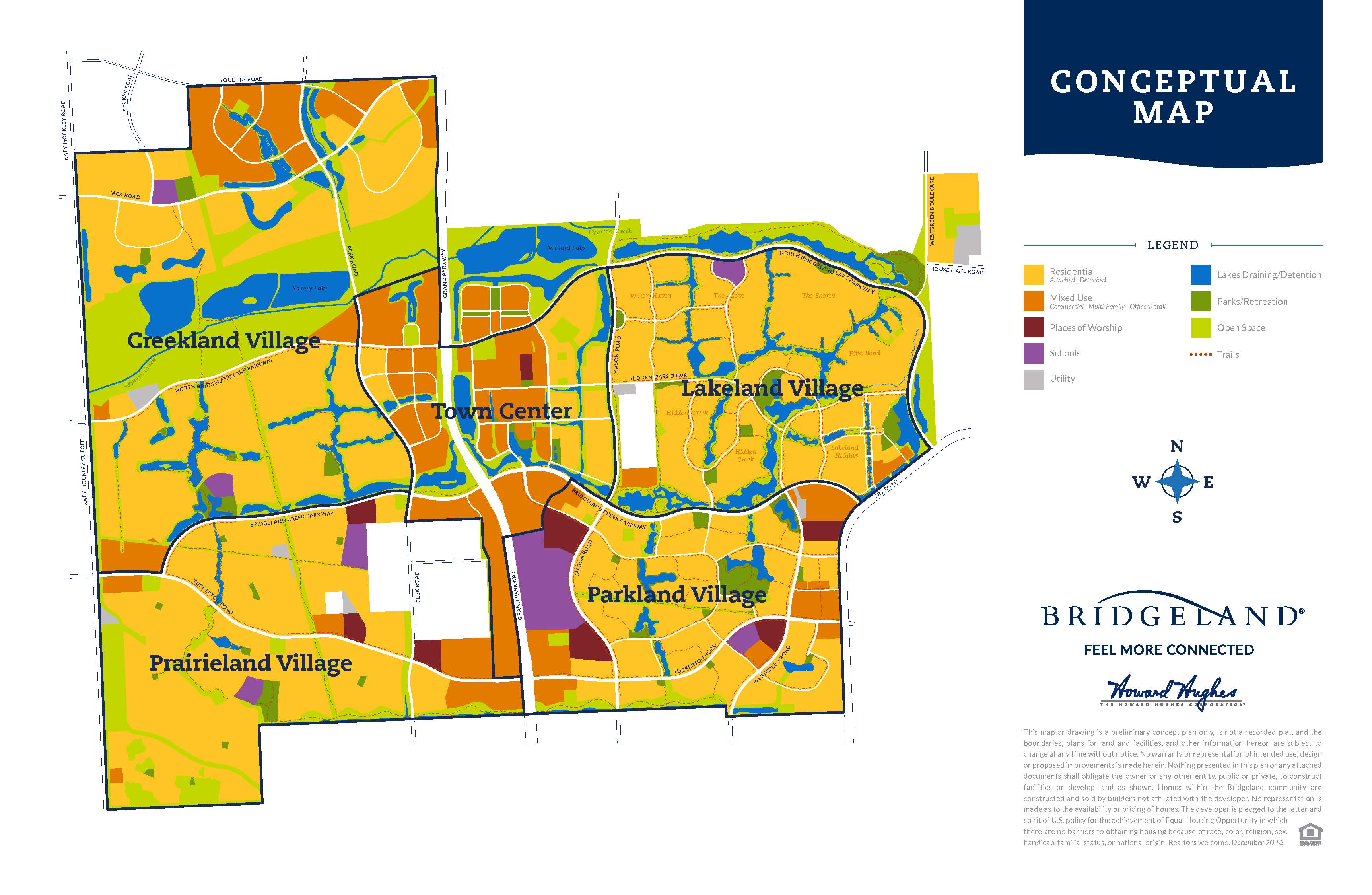
Bridgeland began construction in October 2003, and home sales began in 2006. At buildout, currently estimated for 2037, it will have 65,000 residents on its 11,400 acres. The first of Bridgeland’s four planned villages, Lakeland Village, is almost complete, with 8,300 residents in 3,400 homes; Parkland Village, the second village, opened in spring 2018. Lakeland Village fills most of the northeastern quadrant of Bridgeland, Parkland Village the southeast quadrant, Prairieland Village the southwest, and Creekland Village the northwest. At the site’s center, along Grand Parkway, a future 900-acre Bridgeland town center is planned.
Even by east Texas standards, the site has “no topography, and [has] soil with a high clay content, which means there’s little percolation,” says Heath Melton, vice president of master-planned community residential development at the Howard Hughes Corporation. Combined with the Gulf Coast’s intense summer rainfalls—three inches of rain can fall in 30 minutes, according to Mark Gehringer, senior project manager at Bridgeland—drainage is a key consideration for any potential master plan, and flooding is a risk anywhere, anytime.
Unlike the Woodlands, the Bridgeland site was a relatively treeless, flat, and once-marshy expanse of the vast Katy Prairie west of Houston, but later plowed under for rice farms and used as ranch land. Although the site is almost entirely flat, with a mere 0.05 percent slope from west to east, its sheer size means it outfalls into two primary watersheds. Cypress Creek runs along and across the north edge of the site, flowing from west to east across Houston’s north suburbs. The south edge of the site drains to Langham Creek, an intermittent stream roughly at Bridgeland’s southern boundary that flows southeast into the Addicks Reservoir and ultimately into Buffalo Bayou (see ULI Case Study, Buffalo Bayou Park).
Bridgeland includes much of the 5,000-acre watershed of K150, an intermittent feeder into Cypress Creek that flows generally northeastward through Lakeland Village and meets the creek at the site’s northeastern corner. K150’s streambed is the basis of Bridgeland’s detention, conveyance, and recreational corridor spanning the site from west of the Grand Parkway, east along the north edge of Bridgeland Creek Parkway, and north until it outfalls into Cypress Creek.
Planning and Design
The basic infrastructure networks that define the site layout are its transportation network and drainage network.
In addition to Grand Parkway, six major thoroughfares span or border the site in both the north–south and east–west directions. These thoroughfares facilitate longer-distance trips with synchronized signals and no driveways, have rights-of-way at least 120 feet wide with landscape setbacks of 25 to 65 feet, and sit above the base flood elevation. Three span the site east–west: North Bridgeland Lake Parkway, which runs along its northern edge; Bridgeland Creek Parkway, which bisects the site; and Tuckerton, which runs along the southern edge. North–south thoroughfares include Westgreen, Mason, and Peek.
Secondary collector roads connect individual residences to services and amenities both within and between villages. These have two lanes and 60-foot-wide rights-of-way, with wide, 25- to 45-foot roadside landscape setbacks. Neighborhood streets discourage through-traffic with curvilinear routes and limited entrances. A pedestrian trail network combines sidewalks with a network of off-street trails; many follow waterfronts, which allows the trails to pass beneath thoroughfare bridges.
Parks and Landscape
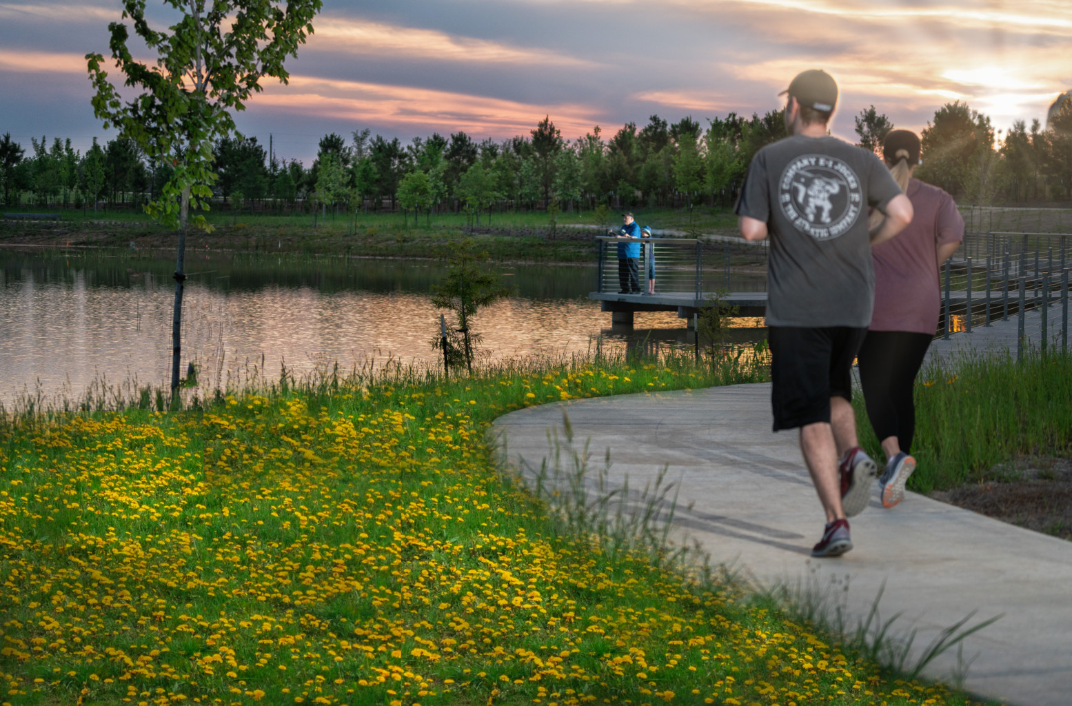
When complete, Bridgeland will have over 3,000 acres of open space, including 900 acres of lakes, 400 acres of parks, and 250 miles of interlaced trails, positioning parks within a quarter-mile of every home.
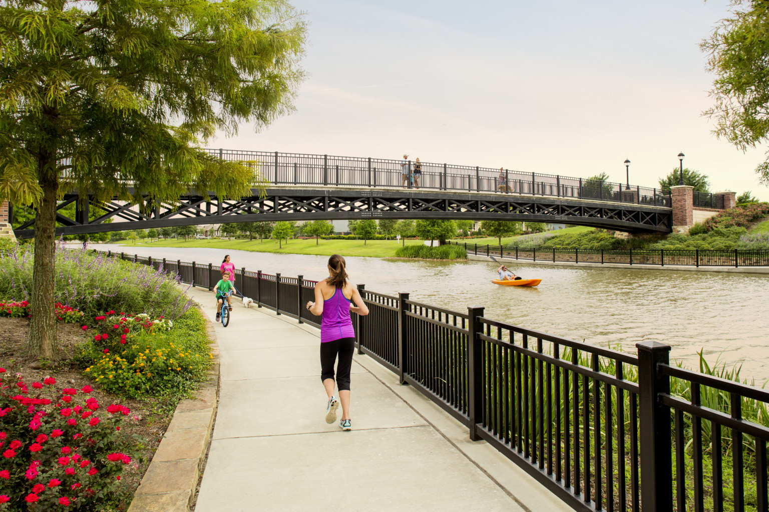
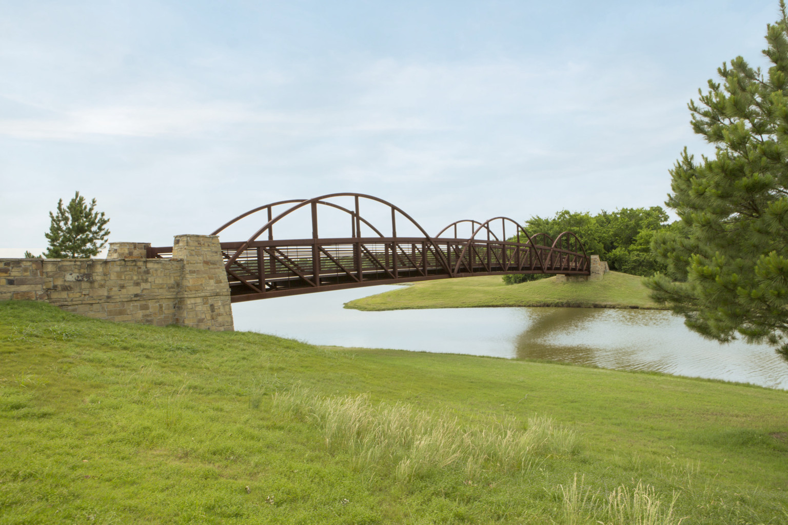
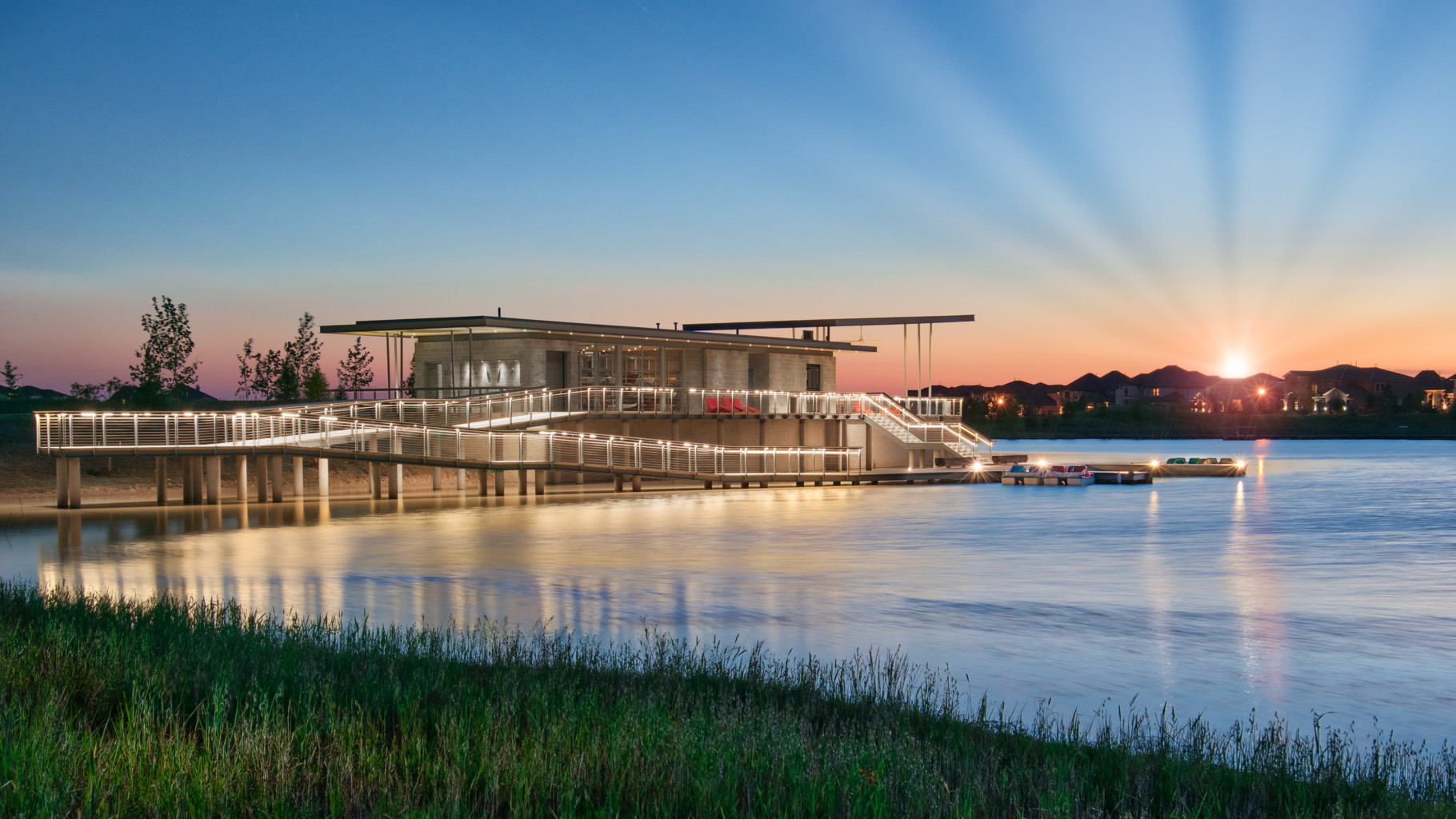
As befitting its name, Bridgeland is centered on miles of lakes crossed by numerous streets, some on actual bridge structures, but most across enhanced culverts sized to manage water flows. Boathouses offer homeowners use of canoes and kayaks on the two-mile-long Cypress Lake or the three-mile-long Josey Lake. An island within Josey Lake’s upstream pool is punctuated with a two-story birding tower, accessed by a skybridge that sweeps across the lake and offers unobstructed views of the lake, which stretches for a mile to the west, east, and south. It engages visitors with the environment with fixed binoculars and interpretive signs introducing local wildlife.
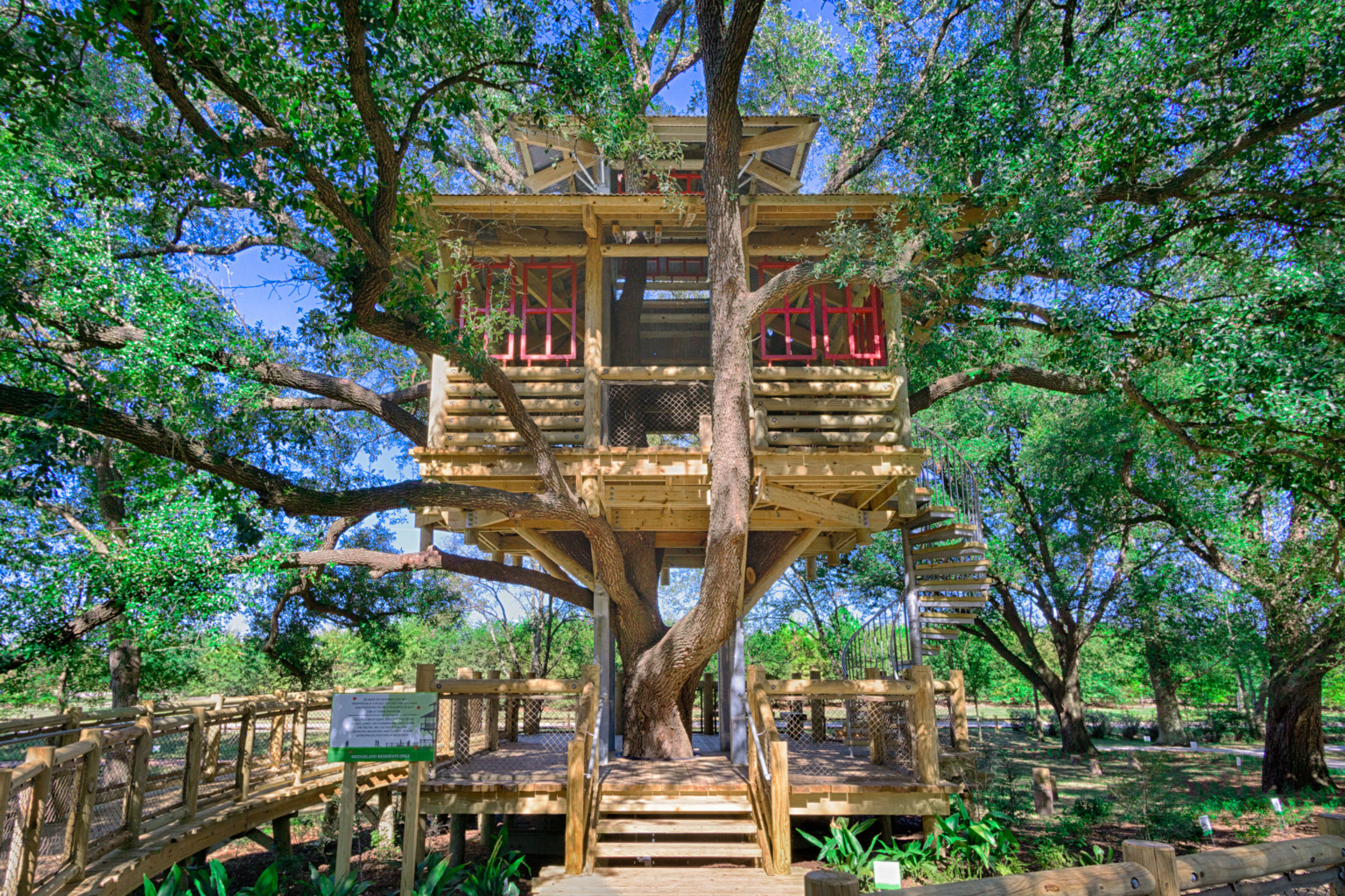
Playgrounds are scattered throughout the site, as are small green spaces with special focuses—for instance, Tree House Park, where a two-story aerie sits within the branches of a century-old oak. Active-recreation amenities are clustered into larger community parks, including two within Lakeland. The 20-acre Village Park contains a pool, a skate park, a dog park, tennis courts, and basketball courts; the six-acre Activity Center within Lakeland Village has an indoor community center and swimming complex. In addition to conventional swimming pools, three “spray parks” offer relief from the summer heat.
Several other open spaces took cues from preexisting elements on the site. An overgrown farm levee that separated the rice fields from Cypress Creek is now a wooded ridgeline trail for mountain biking and hiking. Parkland’s future community park was sited within one of the site’s few forested areas, and the wooded K150 streambed remains as a greenway to buffer homes from a busy road.
Other open spaces repurpose land set aside for other infrastructure. Two east–west trails spanning Lakeland Village and Parkland Village make use of a preexisting road right-of-way and a pipeline easement offering easy connectivity to school campuses with minimal interaction with vehicular traffic. Several drill site areas also have been repurposed for open space and passive open play areas.
As Parkland Village launches, HHC is shifting Bridgeland’s planting palette from manicured lawns to more informal, meadow plantings, mirroring what HHC feels is a shift among buyers to emphasize their own connections with nature. This shift permits broader swaths of meadow and prairie-like grasses in place of lawns along roadside verges, near entry monuments, and—most important—at lake-edge wetlands. Melton commented that local bird watchers have already noticed an increase in species sighted at the first few areas that incorporate this planting palette.
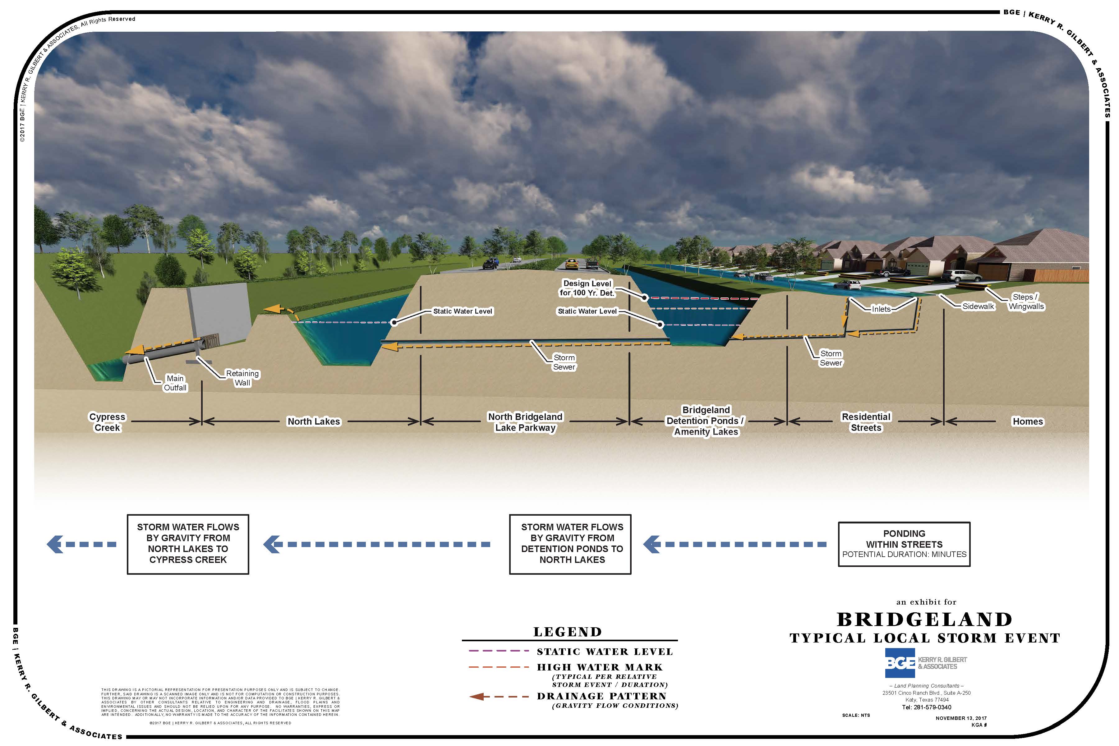
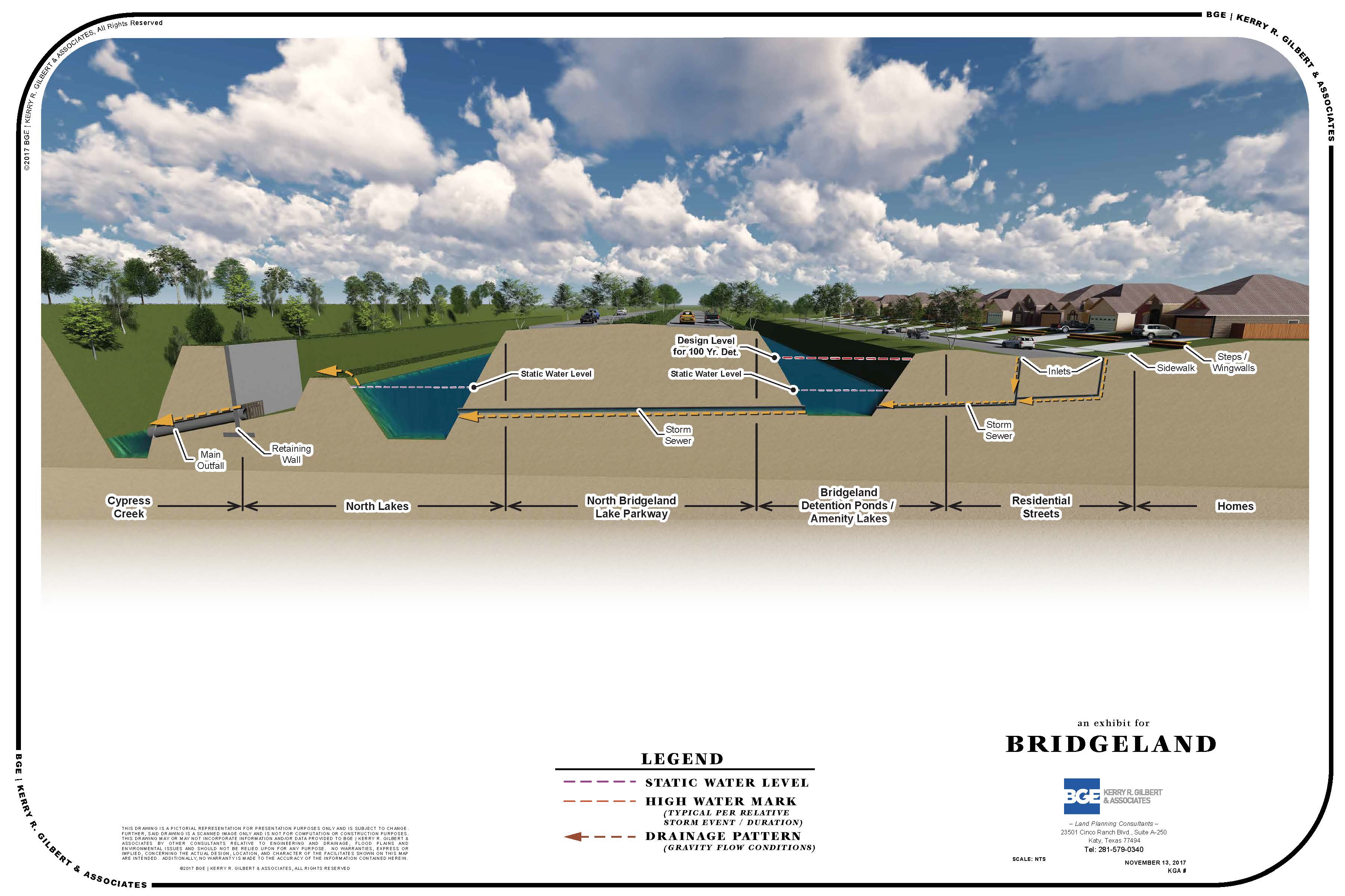
Stormwater System
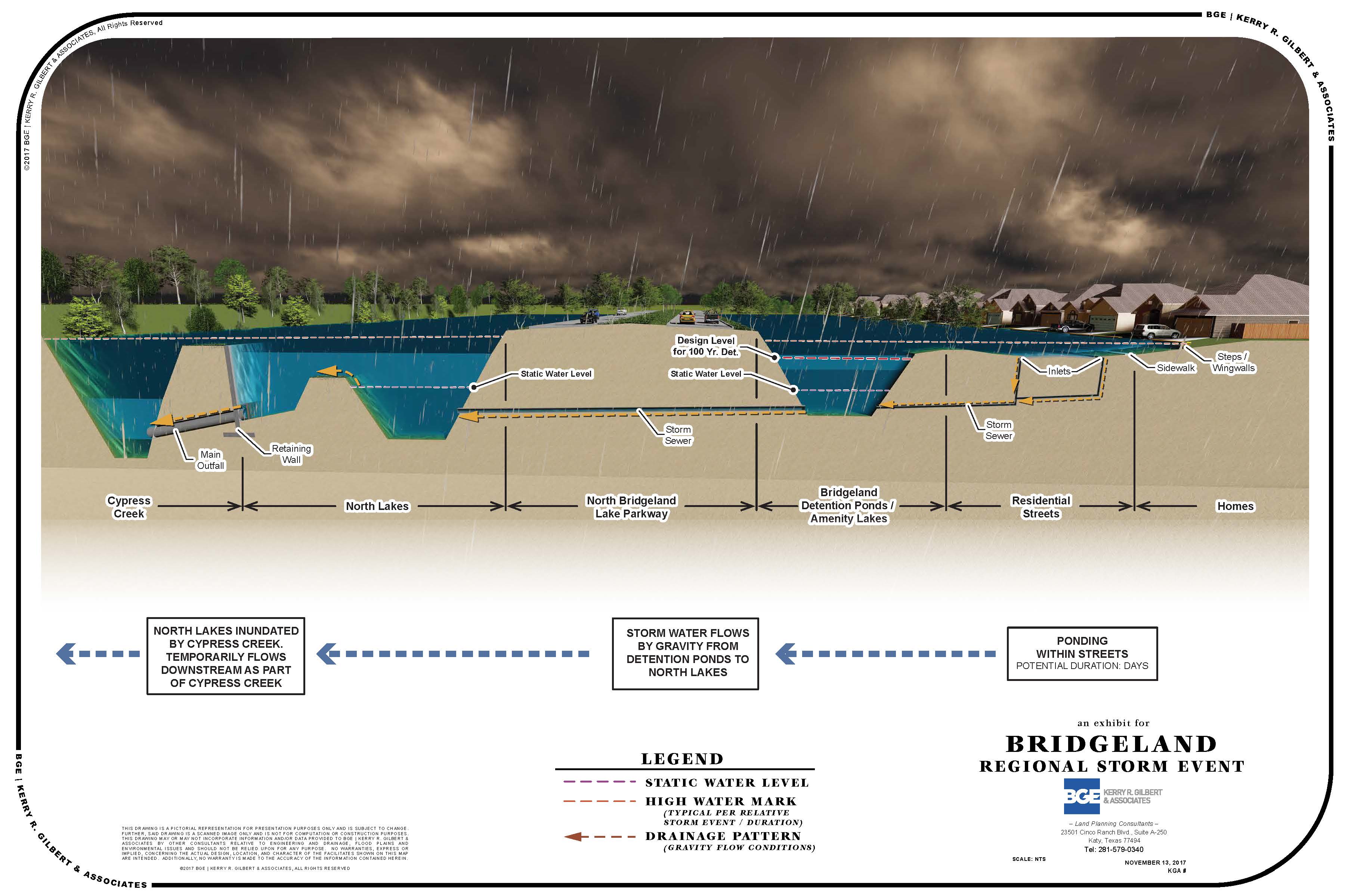
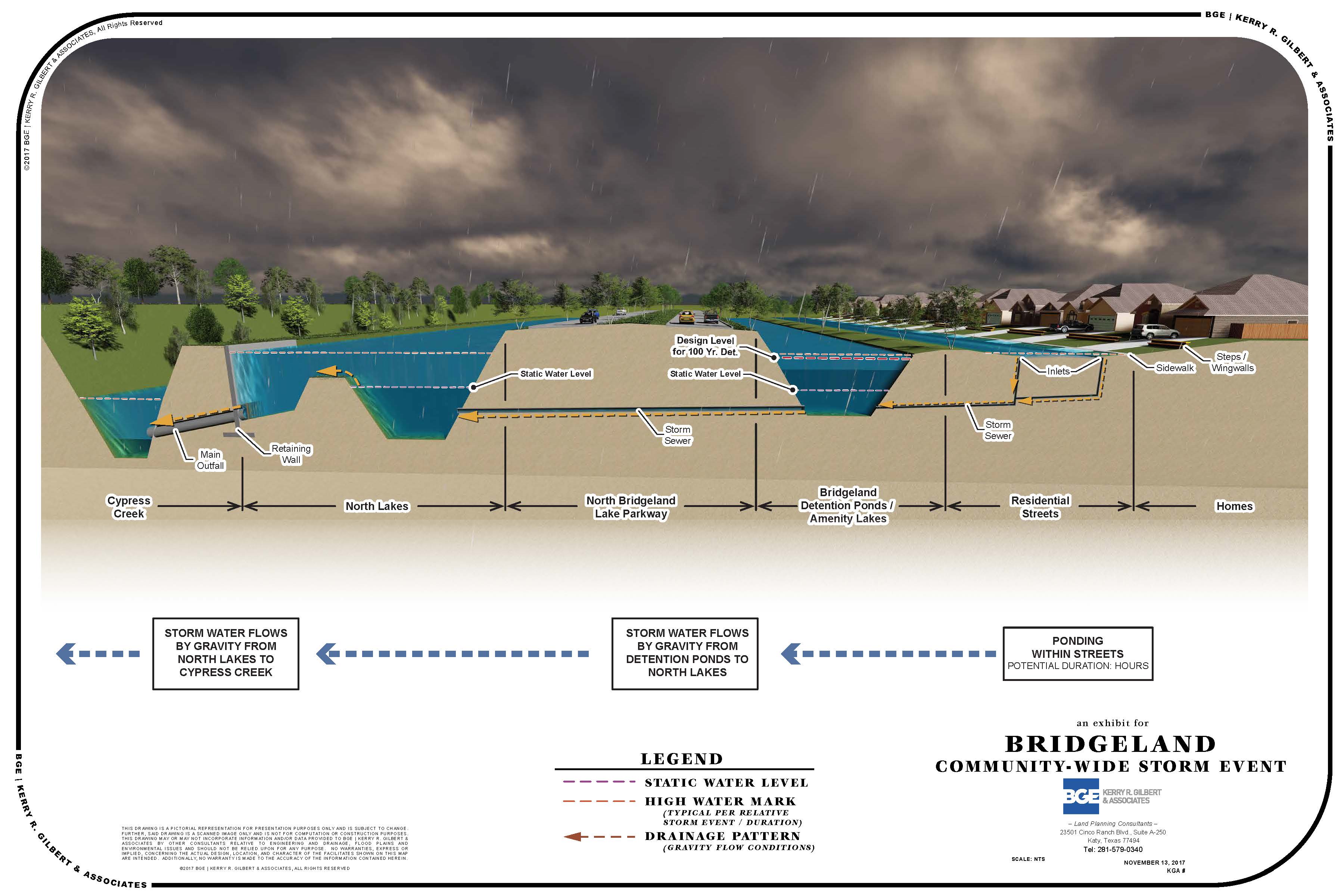
Bridgeland’s stormwater conveyance and detention system design meets or exceeds the requirements of the Harris County Flood Control District (HCFCD), beginning with its requirement to accommodate a 100-year storm. Michael Fitzgerald, the project’s chief consulting engineer, notes, “You can design to minimum criteria, but then you get the minimum resiliency.” Bridgeland’s stormwater system has been tested by two historic flood events: the Tax Day flood of 2016 and Hurricane Harvey in 2017.
Bridgeland front-loaded much of its drainage infrastructure, since Lakeland Village also happened to be where the site drained into Cypress Creek. Drainage was so critical to Lakeland’s execution that “we hired a civil engineer with an extensive drainage background to be our leading project manager,” Melton says.
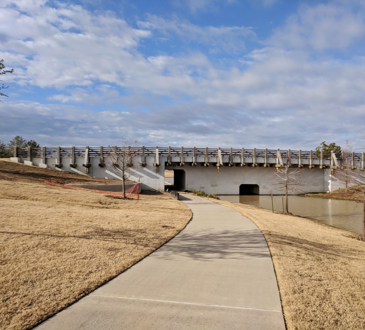
Much of Lakeland Village brackets the stream tributary of K150, now reborn as the 140-acre Josey Lake. Although it has a single name, Josey is divided into a series of stair-step drainage lakes that use culverts that act as detainment or restriction points; their seven-foot-wide openings allow kayakers to pass through, and the roads above are given bridge-like railings in keeping with the community’s name.
Bridgeland Creek Parkway will run along the south shore of Josey Lake across much of Bridgeland’s east–west expanse, ensuring wide vistas even as the site develops. A greenway corridor between the lake shore and parkway creates a central spine with few road crossings, and pedestrian underpasses that double as stormwater conveyance channels connect underneath the parkway. Few houses back onto the parkways; instead, single-loaded streets ensure that passersby see homes’ front or side elevations.
Josey Lake cuts a new channel through the northeast corner of Lakeland Village; a one-mile segment of K150’s streambed near the site’s eastern boundary no longer flows directly into Cypress Creek, but instead acts as a dry and wooded channel flowing west into the lake. Rerouting K150, along with an open park (used as a disc golf course) along Cypress Creek, ensures that stormwater flow is contained within Bridgeland rather than spilling onto adjacent parcels to the east.
The lake was designed with eight feet of freeboard (unused stormwater capacity) and gently sloping edges that range from 6:1 to 10:1, instead of the maximum 3:1 slope allowed by county regulations. This allows for soft lake edges, and a wider green buffer between the lakes and homes. Aquatic plantings in many locations create a gradual transition zone and help minimize sediment from surface flows from the lakes. Open-space features near the lakeshore, including the birding tower, the aforementioned boathouse, a fishing pier, and an event lawn, are designed for immersion during significant rain events.
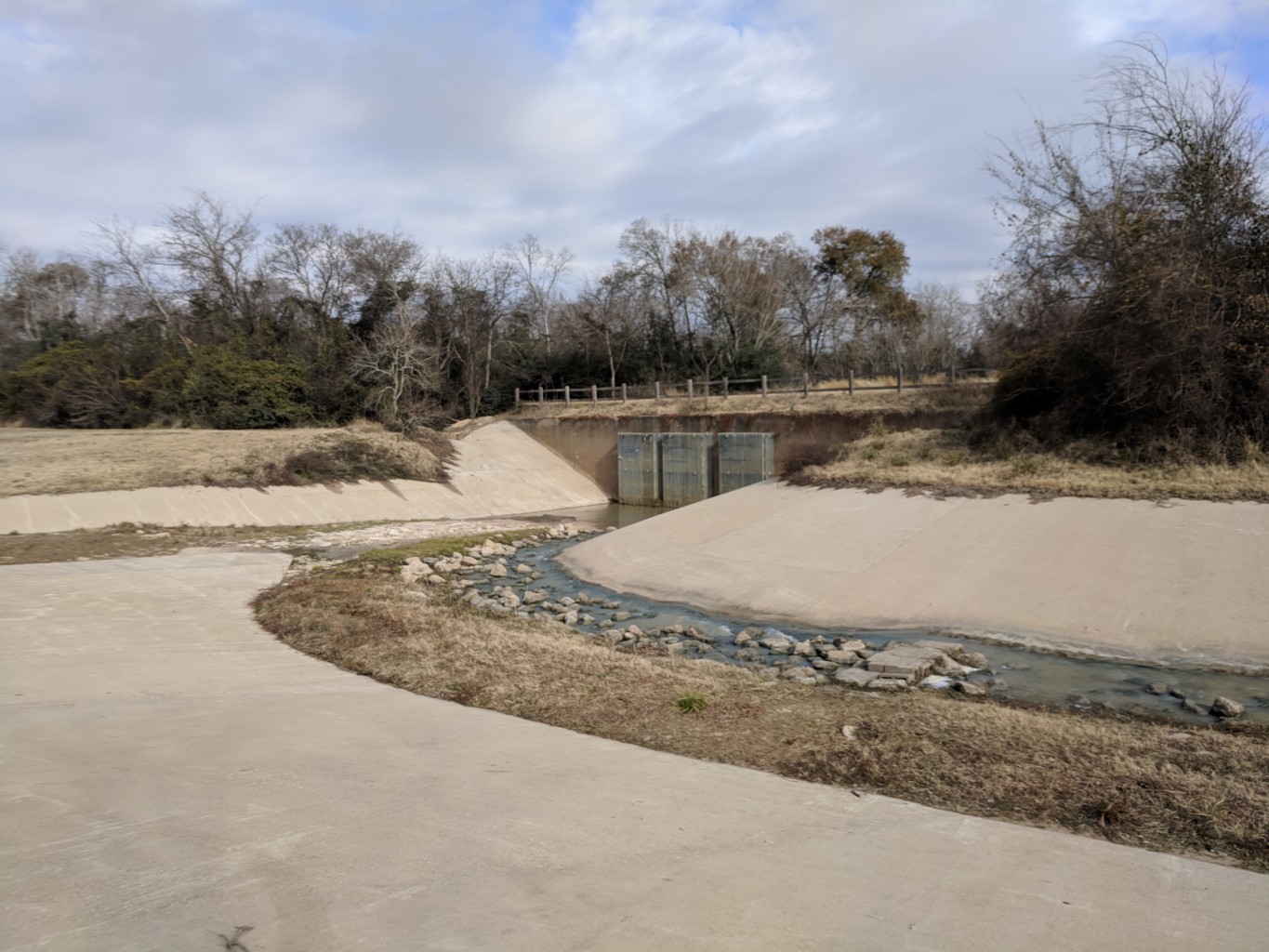
Josey’s final pool, at the north edge of the site, is separated from Cypress Creek by a level control structure (with six inches of freeboard) and an overflow channel. The three, five-foot-wide outfall pipes from that channel through the levee are the outfall into Cypress Creek for a majority of Bridgeland; they are cleaned of debris after each half-inch rain and are recertified annually by the HCFCD.
The Y-shaped overflow channel also drains overflow from another long lake, Cypress Lake, that runs along the north edge of the site; it is separated from Josey by a low berm, and from the creek valley by the Nature Trail atop the former farm levee. Cypress Lake was dug as on-site flood storage to compensate for regrading that lifted other parts of Lakeland Village out of the 100-year floodplain.
Bridgeland’s primary wetlands mitigation area begins around Mallard Lake, a former rice irrigation reservoir north of the future town center. It incorporates a 1,600-foot-wide corridor that stretches to the western boundary of the site.
Bridgeland’s southern edge drains into a different watershed, Langham Creek, where the HCFCD has taken a novel approach for Houston with its Langham Creek Frontier Program. This regional detention strategy combines an on average 700-foot-wide drainage easement, with a 14-foot-deep grade, and impact fees paid to the HCFCD. Most of the channel will be dry, except for one- to two-acre “plunge pools” along its length. Unlike with K150, where the entire basin sat within Bridgeland, negotiating the Frontier Program design implementation required more than three years of collaboration between three property owners and the HCFCD.
In Bridgeland, fill excavated from lake basins is used to elevate the subdivision sites. Street and utility excavation spoils further raise many finished lots. While Harris County requires finished floor elevations (slabs) to be 18 inches above a 100-year storm, a common practice in Bridgeland is to deliver lots at that elevation, putting foundation slabs even higher. “[These] step-ups at each of the lots . . . allowed the houses to sit higher on the lot, resulting in a higher amount of flood risk reduction,” says Gehringer.
As elsewhere in Houston, streets are an integral part of the stormwater conveyance system. Storm drains elsewhere can convey a two-year storm, and otherwise hold water in the streets. In Bridgeland, many of these drains are also oversized.
Water Sources
The extensive on-site lake system also is key to Bridgeland’s drought resilience strategy. East Texas is not only flood-prone but also drought-prone, and having adequate water on site is key to reducing long-term landscape maintenance costs. Landscape irrigation at Bridgeland can tap into four different sources. The first is from the site’s stormwater sources, including Josey Lake and Cypress Lake. The second source is recycled wastewater, which is treated at an on-site plant and pumped into the lake system. A third option consists of using water rights where water can be withdrawn directly from Cypress Creek. On-site nonpotable groundwater wells provide the fourth and last-resort option. The entire irrigation system is distributed to public areas via an separate nonpotable (purple pipe) system, pressurized by multiple pump stations.
Product
“Given its outer-suburban location and proximity to schools, Lakeland Village was always going to be family-centric, so the lot sizes and home products were geared toward families,” says Melton. As the project has grown, it has started to encompass a broader range of homes that appeal to different household types and price points, with lots ranging from 40 to 110 feet wide, and average about three to four units per acre.
One of Bridgeland’s newer offerings is the Lakeland Heights neighborhood, a traditional neighborhood design consisting of alley-loaded single-family houses. Lakeland Heights surrounds the Village Center, with convenience retail and dining and an active-recreation park, and is a unique offering within the Cypress market. At somewhat higher densities of five to six units per acre, it eases the transition between single-family and multifamily or commercial uses. “It offers a different style of architecture to a different niche in the market,” says Melton. The market niche that Melton cites is known as barbell demographics: younger professionals who might have young children, and active adults, who want a home that is walkable to amenities and the village center and to parks offering classes and events such as concerts and films.
The product mix will adapt as development progresses west across the site. Industrial development and an active-adult cluster are planned for future phases west of Grand Parkway, outside the Cy-Fair school district. As at the Woodlands, the Town Center is planned as the project’s final phase.
Approvals, Finance, and Construction
The principal permitting agency for Bridgeland is Harris County, although approvals are also needed from the city of Houston, since Bridgeland lies within its extraterritorial jurisdiction, the HCFCD, the Federal Emergency Management Agency for remapping floodplain elevations, the Texas Commission on Environmental Quality for water and wastewater systems, and the U.S. Army Corps of Engineers.
Melton gives credit to the county for understanding HHC’s need to plan for the long term at Bridgeland—as with the gentler lakeside slopes, or with the wider arterial road rights-of-way. At first, the county rebuffed HHC’s wider medians and rights-of-way, arguing that the additional grass would cost more to mow. HHC prevailed by pointing out that future widening, if needed, would not require expensive right-of-way acquisition.
Finance
Generally, HHC funds its MPC development through a combination of equity and cash flow. Upfront equity funds the initial outlay of infrastructure and grading, which is repaid through finished-lot sales to homebuilders. From there, HHC describes its MPC business as a virtuous cycle: land sales to homebuilders bring cash flow and residents, which generate demand for income-generating commercial developments, which, in turn, serve as amenities that draw more residents. In 2016, it reported cash margins of 69 percent on its MPC business.
In Texas, new water infrastructure is often financed through receivables from municipal utility districts (MUDs, for water and sewer) and water control improvement districts (WCIDs, for drainage) that are set up to own and manage the resulting systems. These special-purpose tax assessment districts, similar to community facility districts in other states, collect property tax to repay municipal bonds used to reimburse the developer for funding upfront infrastructure costs. Bridgeland contains five MUDs and three WCIDs.
Melton describes MPC budgeting as a timing challenge, “stay[ing] out in front, monitoring [capital expenditures] and absorption while keeping an adequate supply” of lots in the pipeline, while awaiting infrastructure reimbursements from the MUDs and WCIDs.

Performance, Marketing, and Management
In a highly competitive marketplace, Bridgeland’s focus on active recreation, gathering spaces, lake frontage, and connections to nature offers key points of differentiation. Despite the fact that finished-lot and house prices, and monthly maintenance fees, are higher than those at other competitors in the area, sales have been strong: 423 homes closed in 2017, representing an annual increase of 27 percent, making it the 29th best-selling MPC in the United States, according to real estate consultancies RCLCO and John Burns. Bridgeland had record sales—even in 2016, when a lackluster energy sector slowed Houston home sales.
Melton says the opening of its second village puts Bridgeland at cruising altitude: the initial burst of infrastructure spending has abated, and sales momentum has been established. Falling infrastructure costs ease the balancing act of MPC budgeting. By contrast, HHC paused new lot production for a period in 2012–2013 as it regrouped while securing a wetlands permit from the U.S. Army Corps of Engineers.
Amenities
Neighboring planned communities already offered more conventional amenities like golf or a supermarket by the time Lakeland Village opened for sales, which provided Bridgeland with the opportunity to define its market niche through other amenities. One key draw it could offer through its sheer size is land for community facilities, notably the most recent addition of a 127-acre K–12 education campus that opened in 2017, ultimately housing nearly 6,000 students. The campus is located just south of the planned town center and linked to Bridgeland’s trail network.
“Amenity packages within the villages are studied extensively on a national basis utilizing consultants and lots of surveys,” says Melton, pointing to how Parkland Village’s playground integrates natural themes and wooden structures, while its aquatics facilities include a lazy river, a beach-entry pool, and a sundeck alongside the usual lap pool.

Marketing
“Events really put you on the map,” mentions Melton, “and Bridgeland’s scale allows it to make an impact. Annual events are an opportunity to show off Bridgeland to a regional audience.” Many reinforce the community’s slogan of connecting nature and residents. These events have been held along Cypress Lake in the past, but they will move to a dedicated space along Josey Lake in the future. Nature Fest is its signature annual springtime festival that drew 13,000 in 2018, to meet creatures as diverse as hawks, armadillos, reptiles, and ponies, alongside crafts, exhibitors, and a climbing wall. In the fall, Howl-O-Ween, an event geared to four-legged family members, drew nearly 9,000 guests with offerings such as dog stunt shows, a dog fashion show, on-site pet adoption, and trick-or-treating.
A new addition to the event lineup is “Friday Night Bites,” a monthly food truck roundup that allowed Lakeland Village to establish itself as a dining destination long before restaurants began opening at its village center. Its 25 vendors now regularly draw 1,000 patrons.
Management
As at many MPCs, multiple levels of management ensure that community facilities are kept to a high standard. A master Bridgeland Council maintains larger facilities, such as Josey Lake, and coordinates site-wide activities. Each of the villages has its own association, which maintains amenities specific to the village. The MUDs and WCIDs operate the water infrastructure, and the WCIDs also own the lakes and stream corridors.
Most of the streets are public facilities, although private streets are planned in future multifamily or active-adult phases.
Flood Performance
The first big test of Lakeland Village’s drainage network came with the aforementioned Tax Day flood on April 15, 2016, when 15 inches of rain fell within 12 hours at Bridgeland’s western edge. This was calculated as a 600-year event for this area and set new high-water records, both for rainfall and for the water level in Cypress Creek. Even though Josey Lake had not yet been completed at the time, no homes and only isolated thoroughfares flooded. Remarkably, analysis (and aerial footage) after this flood showed that the stormwater system conveyed the local flows as designed. The high-water marks after the flood occurred not from local runoff, but from Cypress Creek exceeding it banks and flowing into Bridgeland’s lakes.
Hurricane Harvey brought a larger and more sustained rainfall, with 17 inches of rainfall over 24 hours, and 27 inches of rain in 48 hours. At Bridgeland’s western edge, the two-day rainfall total was considered a 5,000-year event. Standing water filled many streets (as is expected during an event of this magnitude) and flowed onto many yards, but again, no homes took on water—validating the team’s design standard decision. Remarkably, construction activities were able to resume within two to three weeks. During and after each event, numerous homeowners expressed gratitude for the foresight in planning for flood resilience; one wrote on Facebook, “It was worth paying $30,000 more to live here and not have my house flood.”
The HCFCD and BGE are both modeling all of Bridgeland based on these rainfall events, to learn what worked or what could be taken into consideration for future development efforts. The HCFCD modeling after the Tax Day flood resulted in no changes to the 2009 stormwater designs for conforming subdivisions.
Observations and Lessons Learned
Understanding the site and its possibilities was key to creating a plan that would stand the test of time both from an economic and an environmental perspective, a lesson that the team learned from the Woodlands. “The site ended up with a different feel from the Woodlands,” notes Kolkhorst, and instead, the site plan draws from the site’s broad prairie views and long lakes. “From the second Cypress Lake pedestrian bridge, the long view to the west when the sun is setting is spectacular.” The connections drawn from the site to its site plan are ones that Bridgeland emphasizes through its marketing, which focuses on themes of balance, connection, and bridging the natural and built environments. A site of this scale also makes it easier to mitigate environmental impacts, such as floodplain changes, within the site.
Any project that takes a generation to develop must accommodate adjustments along the way, while also selling those changes to stakeholders who have already bought into the vision. Melton emphasizes that the developer has to be a good storyteller about how the changes ultimately improve upon the initial vision. When HHC shifted the amenities and landscaping to emphasize meadows, prairies, and nature, the team worried about the reception from Lakeland Village residents, who were used to manicured lawns. “Were residents going to accept going from a turf look to a looser landscape? Education can really tell that story, outline the vision, get people to understand, and buy in,” says Melton. “At Josey Lake, residents are absolutely in love with the concept and vision as we transition to different plantings.”
The stormwater system is another key infrastructure element that HHC has realized is an important story it needs to tell. Going beyond the stormwater requirements meant that the system has endured not only 100-year events, but also multiple events of far greater magnitude, and even managed to absorb an unexpected degree of overflow from Cypress Creek. It also exceeds the more stringent floodplain regulations issued by Harris County after Harvey, and has been improved with data learned from the most recent record floods.
“How the stormwater systems work is not obvious to most residents,” says Fitzgerald. Shortly after Harvey, the team was relieved about how well the system performed, but realized the need for better educational materials to provide residents with a level of comfort and understanding as water inundates streets. “We need to do a better job educating the residents in our community about how our drainage systems work. . . . I asked BGE to come up with exhibits that illustrate how the drainage system performs during different events, so when residents see water in the streets, [they know] that it is a function of the intended design,” says Melton. These exhibits will be shared with existing and prospective residents and will be part of an ongoing education effort.
Especially for an MPC, patience pays off in the long term. For instance, HHC made additional upfront investments in the purple-pipe system and perennial grasses along the lakeshores, because they would save on landscape maintenance—an obligation for the homeowners’ association, not even the developer. Even today, Bridgeland’s superior environment earns it a substantial price premium over its comps and sees faster sales.
Project Information
| Development timeline | Month/Year |
|---|---|
| Site purchased | 2004 |
| Planning started | 2004 |
| Construction started | 2006 |
| Sales/leasing started | 2007 |
| Lakeland Village completed | 2018 |
| Project completed | Residential 2035; Commercial 2045 |
| Land use plan - overall | Site Area (acres) | % of Site |
|---|---|---|
| Conventional residential | 3,986.2 | 34% |
| TND residential | 469.1 | 4% |
| Attached residential | 222.6 | 2% |
| Multifamily | 256.5 | 2% |
| Commercial | 432.4 | 4% |
| Office | 355.8 | 3% |
| Industrial | 253.9 | 2% |
| School/churches | 367.9 | 3% |
| Landscaping and active open space | 190.3 | 2% |
| Open space/drainage | 2,531.3 | 22% |
| Transmission/pipelines | 132.7 | 1% |
| Drill sites | 164.6 | 1% |
| Utility | 465.5 | 4% |
| R.O.W. | 1,111.6 | 10% |
| Mitigation | 753.5 | 6% |
| Total | 11,693.9 | 100% |
| Land use plan - Lakeland Village | Site Area (acres) | % of Site |
|---|---|---|
| Conventional residential | 963.8 | 45% |
| TND residental | 176.6 | 8% |
| Commercial | 9.6 | 0% |
| School/churches | 16.6 | 1% |
| Landscaping and active open space | 36.7 | 2% |
| Open space/drainage | 742.6 | 35% |
| Drill sites | 31.8 | 1% |
| Utility | 22.6 | 1% |
| R.O.W. | 131.40 | 6% |
| Total | 2,131.7 | 100% |
| Gross building area - Overall | |
|---|---|
| Use | Building Area (sq ft) |
| Office | 6,150,000 |
| Retail/restaurant | 2,758,400 |
| Hotel | 772,500 |
| Multi-family | 6,236,257 |
| Industrial/flex | 2,575,000 |
| Development cost information | Amount in $ |
|---|---|
| Site acquisition cost | 44,057,793.30 |
| Total development cost to date | 436,291,569.30 |
| Total development cost at completion | 1,795,988,983.30 |
Format
Full
City
Cypress
State/Province
TX
Country
USA
Metro Area
Houston
Project Type
Planned Community or Resort
Location Type
Outer Suburban
Land Uses
Civic Uses
Community Center
Conservation Zone
Education
Fitness Center
Lake
Multifamily Rental Housing
Neighborhood/Community Center
Off-Road Trails
Office
Open space
Planned Community
Recreation
Religious Use
Single-family Detached Housing
Single-Family For-Sale Housing
Streets
Water Uses/Amenities
Keywords
Freshwater reservoir
Graywater reclamation
Healthy place features
Main street design
Mixed-use town center
Park system
Playground
School
Single-family detached housing
Stormwater management
Stormwater reuse system
Town center
Traditional neighborhood development
Waterfront
Site Size
11400
acres
acres
hectares
Date Started
2004
Date Opened
2007
Website http://bridgeland.com/ Address 16919 N. Bridgeland Lake Pkwy. Cypress, TX 77433 Developer Bridgeland Development LP Cypress, TX Owner Howard Hughes Corporation Dallas, TX Prime / Master Planner / Lead Designer LJA Inc. Houston, TX Civil Engineering BGE Inc. Houston, TX Interviewees Daniel Kolkhorst, vice president, land development, Howard Hughes Corporation Heath Melton, vice president, master-planned communities and residential development, Howard Hughes Corporation Michael Fitzgerald, principal, BGE Inc. Mark Gehringer, senior project manager, Howard Hughes Corporation — Bridgeland ULI Staff Ed Walter Global Chief Executive Officer Billy Grayson Executive Director Center for Sustainability and Economic Performance Katharine Burgess Senior Director Urban Resilience Payton Chung Director Case Studies and Publications Principal Author David Kim Executive Director ULI Houston Misty Loocke Senior Manager ULI Houston James A. Mulligan Senior Editor David Rose Copy Editor Erica Ellis Graduate Student Intern Urban Resilience